


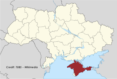
Above: Wikipedia’s map showing Crimea as part of Ukraine.
National Geographic, the venerable and often deeply controversial flagship organization of the American field of geography, has generated a new firestorm over its decision to start mapping Crimea as part of the Russian Federation following its illegal and fraudulent annexation of the peninsula. Other options would include marking it as “disputed” or still part of Ukraine. Nat Geo’s justification was that they “map the world as it is, not as people would like it to be.”
Whether or not the de facto status of Crimea is now that it is part of Russia, that’s a cop-out. And as someone who studied the history of geography at the University of Delaware’s nationally prominent Geography Department, I’d like to point out that this cop-out also conveniently absolves National Geographic of its role in the community and the world, one which has historically been both very important and very damaging (in many cases).
Geography, a field which many Americans don’t know is much broader than maps and country names (cartography), is inherently about how people interact with their landscapes, culturally and politically. It’s still a field that’s taught in public schools in the United Kingdom, Australia, and most other Commonwealth nations. But it fell out of favor a long time ago in the United States, where it has been folded into social studies at a very basic depth (e.g. learn the names of the U.S. states and you’re done). While this is often mockingly written off as American ignorance — think the woman from South Carolina struggling to talk about “the Iraq” — it’s actually more complicated than that as to why geography disappeared in the United States a while ago.
The short version of the most relevant reason here is that the U.S. Geography community’s establishment — led by none other than National Geographic — in the 1910s, 1920s, and 1930s became tragically wrapped up in and obsessed with junk science purporting a “geographic determinism” that supported other popular racist (white supremacist) theories aiming to “prove” whites were the superior race. In the United States, the field of geography became intertwined with other junk fields like social darwinism and phrenology (the study of the human cranium to reveal ‘inherent’ character or mental abilities), or its successor craniology (purporting to show a race/head size link), as well as the segregationist and Nazi sympathizer movements ascendant in the period. This is the era when the KKK was reborn in the American South and Hitler was planning to start murdering millions of people based on the same theories. Meanwhile, there is National Geographic and friends telling people that these policies are ok because “tropical peoples” are inherently lazy due to having “evolved” in oppressively hot climates. (Something that now seems transparently absurd to most of us.)
So, after World War II, people with sense (… and a sense of shame) began to criticize the corrupted field of American geography and it fell from grace. That actually is deeply unfortunate because geography as a complete discipline has much to offer in terms of explaining our natural and built worlds, the way we engage them, and how we can make them better. In recent decades, for example, we have also seen sub-fields arise to promote the study of the geography of women, sexual and gender minorities, or persons of color — as in how those communities interact with environments differently from how white cisgender heterosexual men behave in the same environments — which is a very positive development that broadens our understanding of the worlds we have created.
But regardless of that, it is certainly true that geography as a field has always been and always will remain at least partially very political, as the shameful history of the U.S. Geography establishment will forever remind us. Geography will never be an objective, indisputable arena. It’s an attempt to translate to paper and quantify something massively complex and inherently partially based on individual human perception. Even the cartographic (mapmaking) activities surrounding the most banal things always fits within a broader context that creates room for disputes.
For whatever it’s worth (and however long it lasts), I’d note that Wikipedia has so far taken the approach of splitting the difference by having a page and map for “Crimea,” the physical peninsula, as part of Ukraine (the global community’s view), while creating a separate “Republic of Crimea” page and map for Crimea as a part of Russia (Russia’s view).
Michael Blanding at Slate has a good discussion of just how politicized the fields of geography and cartography can get, in light of Nat Geo’s move on Crimea. I encourage people to read the whole thing, but here is an illustrative excerpt:
India, Pakistan, and China all use different maps to define the boundaries of Jammu and Kashmir. Moroccan maps include the disputed area of Western Sahara as part of the kingdom. China uses ancient maps to assert its legitimacy over Tibet. Israelis and Palestinians refer to maps created in 1919 and 1947 as the basis to claim their own boundaries. And deserted islands the world over change color on paper depending on which country is mapping them.
If you think about it, it’s genuinely amazing the extent, for example, to which discussions of the Israeli-Palestinian conflict revolve around phrases like “pre-1967 borders” or “1947 UN Partition plan.” Even if you haven’t looked at it that way before, the reality is that geography and the haggling over how that geography is presented, has a huge impact on those discussions.
He continues:
The fact is, the very act of trying to render three-dimensional geography on a flat surface forces the mapmaker to make choices about what to include and how—and that includes interpretations about who they think controls what. As maps of territorial claims over the years in Africa, Asia, and North America have shown, those depictions can then have a big influence on later events.
If history is any lesson, then as the conflict in Crimea plays out in the coming weeks and months, the maps made of the region may not only reflect the reality on the ground, but also help create it.
Russia rolling into Crimea, seizing all government institutions and military bases, then holding a near-unanimous referendum, and formalizing annexation — all within a matter of a few weeks — was an intentional strategy to present the Crimea takeover as a decisive fait accompli before the world could figure out how to stop it. National Geographic is endorsing that strategy by solidifying the new “de facto” reality on the ground into their maps of the world and the region. That’s going to be a huge boost to trying to prevent the world from reversing what has happened.
The ink is barely dry on the annexation “agreement” between Crimea and the Russian Federation. Why rush to hand it over on the maps? National Geographic has an obligation to recognize the importance they play on the world stage and can’t get out of it by pleading neutrality and objectivity in an inherently political discipline.