Why hasn’t their popularity faded? Didn’t we expect them to collapse months ago? How are there still supporters who don’t realize how terrible this is? Donald Trump: the ISIS of candidates.
![]()


Why hasn’t their popularity faded? Didn’t we expect them to collapse months ago? How are there still supporters who don’t realize how terrible this is? Donald Trump: the ISIS of candidates.
![]()
Arsenal Bolt: Quick updates on the news stories we’re following.
![]()
“IS: Neither Islamic nor state, but is it a caliphate?” Mamoon Alabbasi for Middle East Eye — Observers argue that IS is neither Islamic nor a state, but what legacy would it have as a ‘caliphate’ compared to some of its predecessors?
“There are other aspects of the caliphate throughout the history of Islam that are worth noting – aspects that fly in the face of IS’s declared war on anyone who does not share their particular interpretation of the faith,” said Lyons, who is also currently working on a revisionist history of the Muslim world.
“Chief among these was the remarkable ethnic, linguistic and religious pluralism that characterised the institution for much of its early history, a fruitful mixing of cultures and traditions which made the Islamic empire of the late medieval period the leading world centre of science, philosophy and culture,” he added.
In some eras during the history of that caliphate, the treatment of minorities and the promotion of education particularly stood out in stark contrast to IS’s inflammatory rhetoric to anything that originates from what they perceive as outsiders.
“Under the Abbasid caliphs, who made Baghdad their capital in 762 CE, the Islamic empire greedily absorbed learning from disparate traditions and cultures – Jewish, Hindu, Zoroastrian, Syriac Christians and pagan – as a matter of state-sanctioned intellectual policy,” said Lyons.
“Abbasid scholars then went on to new heights in philosophy, medicine, mathematics, astronomy and other sciences, achieving breakthroughs that later laid the foundation for Europe’s own scientific and intellectual development,” he added.
The essay below was co-authored with Stephan Richter, Editor-in-Chief of The Globalist, where it originally appeared.

A U.S. Air Force Boeing KC-135R Stratotanker from the Ohio Air National Guard at Incirlik, Turkey, August 2003. (U.S. Air Force photo by Tech. Sgt. Vince Parker.)
To recruit Turkey against ISIS, the United States lost sight of its true friends.
U.S. policy on Iraq, Syria and the surrounding countries seems to have been left solely in the hands of amateurs in the White House. That is not a partisan statement, for it applies to both the current and previous occupants. The next occupant, regardless of party, seems likely to muck it up as well.
The latest foolhardy decision seems to have been a deal long sought by the United States to move the “strategy” against ISIS forward. It is worth recalling that the terrorist organization is de facto an American creation resulting from the completely ill advised Iraq policy under George W. Bush.
In the blinding desire to destroy ISIS, Mr. Obama and his team were so keen on getting rights to use Turkish air bases that they completely forgot about the dark side of Mr. Erdogan.
No sooner had the agreement on bases been reached than Turkey’s own aircraft began pounding Kurdish militant targets in northern Syria and Iraq.
The government, which still lacks a governing mandate after no party won a majority in the recent elections, has officially put the anti-ISIS PKK fighters on the same threat level as ISIS. In reality, Kurdish fighters appear to be a much bigger target of the Turkish Air Force than the ISIS fighters.
The point of all this maneuvering is that Erdogan hopes to leverage wartime fervor into a favorable nationalist coalition or a new election with a better outcome for himself.
As if the U.S. collusion in that domestic, entirely partisan strategy would not be shameful enough, the United States is also pledging to help Erdogan on another matter. He has long sought to clear an ISIS-held area of Syria that is coveted by both Kurdish nationalists and (pro-Erdogan) Ottoman irredentists in Turkey. The latter, it seems, still have yet to accept the country’s 1920s borders.
Hard though it may be to believe, the facts on the ground are as follows: The U.S. military is now helping Turkey’s hardliners achieve their goals against the very Kurdish fighters whose close coordination with U.S. bombers have pushed ISIS back from Kobani and disrupted its supply lines. All the while, Turkey sat on its hands and refused to halt lucrative ISIS smuggling.
In effect, the Americans managed to sell out the Kurds, perhaps Syria’s only remaining true “freedom fighters,” as they proved to be in the defense of Kobani. Read more
Arsenal Bolt: Quick updates on the news stories we’re following.
![]()
“Syria rebels sceptical about Turkey’s plan to tackle IS” – Financial Times wire via the Irish Times:
“The talk of a buffer zone surprised us – we have heard nothing like that,” said Munthir Sallal, a rebel official co-ordinating with the coalition who said rebel commanders met Turkish officials in Ankara yesterday.
[…]
An opposition activist close to the US confirmed plans for increased Turkish participation with the coalition, which began dispatching the first rebel units it trained and armed earlier this month.
The coalition has also been training activists from opposition councils in areas seized by IS to ensure a smooth transition to civilian rule.
But opposition members say they have been repeatedly promised by Turkey and the US that operations were imminent, and are sceptical.
Previously from AFD on this topic:
– “Mapping the projected Turkish occupation zone in Syria”
– “U.S. agrees to clear a ‘safe zone’ in northern Syria”
The deal being reported so far does not involve a no-fly zone against Assad, just more targeted U.S. bombing against ISIS from the air, as well as Turkish shelling (and maybe bombing) from across the border — but no ground occupation. Instead, the U.S. will provide airstrikes on behalf of Arab rebel fighters who aren’t affiliated with ISIS. That revives an old plan I’ve criticized previously, except now those fighters we would be helping are even more likely to be aligned with al Qaeda. Kurdish fighters would also be definitively excluded from assistance west of the Euphrates, it seems, to assuage Turkish antipathies.
“Turkey and U.S. Plan to Create Syria ‘Safe Zone’ Free of ISIS” – New York Times:
“Details remain to be worked out, but what we are talking about with Turkey is cooperating to support partners on the ground in northern Syria who are countering ISIL,” a senior Obama administration official said, using another term for the Islamic State. “The goal is to establish an ISIL-free zone and ensure greater security and stability along Turkey’s border with Syria.”
[…]
American officials say […] that while a de facto safe zone could indeed be a byproduct of the plan, a formal no-fly zone is not part of the deal.
[…]
Instead, United States officials said Turks and Americans were working toward an agreement on the details of an operation to clear Islamic State militants from a heavily contested area roughly between the eastern outskirts of the city of Aleppo and the Euphrates River.
That is an ambitious military goal, because it appears to include areas of great strategic and symbolic importance to the Islamic State, and it could encompass areas that Syrian helicopters regularly bomb. If the zone goes 25 miles deep into Syria, as Turkish news outlets have reported, it could encompass the town of Dabiq, a significant place in the group’s apocalyptic theology, and Manbij, another stronghold. It could also include the Islamic State-held town of Al Bab, where barrel bombs dropped by Syrian aircraft have killed scores, including civilians, in recent weeks.
American officials emphasized that the depth of the buffer zone to be established was one of the important operational details that had yet to be decided. But one senior official said, “You can be assured many of the principal population centers will be covered.”
The plan does not envision Turkish ground troops entering Syria, although long-range artillery could be used across the border. Turkish ground forces would work on their side of the border to stem the Islamic State’s ability to infiltrate foreign fighters and supplies into Syria.
While it is unclear yet exactly how big the area will be, and supposedly there won’t be Turkish ground presence, I previously made a projected estimate in the following two maps (see details and analysis at “Mapping the projected Turkish occupation zone in Syria”):
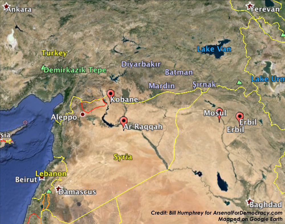
Regional View: July 24, 2015 projection of the perimeter of a potential Turkish occupation zone and U.S. no-fly zone in northern Syria. Click to enlarge.

July 24, 2015 projection of the perimeter of a potential Turkish occupation zone and no-fly zone in northern Syria. Click to enlarge.
I seem to have guessed the zone’s width correctly (outskirts of Aleppo to the Euphrates) and the depth may supposedly still be under discussion, but if it includes Manbij and Al-Bab, then I also pretty much will have nailed the depth estimate, because it is likely the whole M4 highway from corner to corner would be the southern perimeter of the zone. However, the Times is merely quoting the same Turkish media reports I was working off of, so we don’t actually know yet. A much narrower “strip” encompassing many fewer “principal population centers” (and outlying villages) could terminate at the highway shown above in the middle of the zone, nearer Marea than Aleppo.
Arsenal For Democracy estimates and maps the perimeter dimensions of Turkey’s potential occupation zone / U.S. no-fly zone in northern Syria. (The detail map is near the middle, after the evidence used to prepare it. A regional map showing the area in context is attached at the end.)
As I’ve explored previously, for the past month, the Turkish military and the Turkish government have been disagreeing quasi-publicly as to whether to invade and occupy northern Syria to establish a “humanitarian zone” (supposedly for refugees).
The military brass is trying to delay at least until a new government is formed and the newly-elected parliament can take a vote on it, while the ruling AK Party is pushing for an intervention sooner. It seems to have been an AK Party aspiration, off and on, since at least September 2014, whereas the military isn’t entirely sure it’s a good idea in a general.
On February 22, 2015, Turkey’s military staged a lightning incursion in and out Syria, moving more than 600 troops and 100 tanks along the Euphrates River for some 22 miles (35 km) and then returning to the Turkish border a few hours later. The objective then was ostensibly to secure and re-locate a historic tomb of national significance (which was being guarded by Turkish Special Forces in a vulnerable position). But it may have also served to test Turkey’s ability to invade that far into Syria’s warzones without major resistance, although it was on the other side of the river, south of Kobani.
Of course, a speedy raid and departure would be quite different from a full-scale intervention to hold territory indefinitely. So how big of an area are we actually talking about for this possible massive military operation?
Soner Cagaptay, the director of the Turkish Research Program at The Washington Institute, indicated in The Globalist in early July (based on “media reports”) that the zone would be as follows:
Specifically, Turkish forces may be aiming to seize a [88-km] 55-mile-long stretch of territory from Azaz in the west to Jarabulus in the east, thus establishing a [32-km] 20-mile-deep cordon sanitaire against the violence next door and creating a staging ground for pro-Turkey Syrian rebels.
Following meetings between U.S. and Turkish government officials this week, Turkey’s Hurriyet Daily News reported the latest rumors, which were far more expansive:
A recent joint action consensus between Turkey and the United States, which includes the use of the İncirlik Airbase in southern Turkey in fight against the Islamic State of Iraq and the Levant (ISIL) jihadists, also covers a partial no-fly zone over the Turkey-Syria border, according to sources.
The 90-kilometer line between Syria’s Mare [Marea] and Cerablus [Jarabulus] will be 40 to 50 kilometers deep, sources told daily Hürriyet, while elaborating on the consensus outlined by Deputy Prime Minister Bülent Arınç, following a cabinet meeting on July 22.
However, sources avoided saying whether such a zone would be broadened in the future.
In addition to that representing a larger area, this news also suggests Turkey’s longstanding demand of getting U.S. air support and a no-fly zone for such an operation may have been met.
If it comes to pass with those enlarged specifications, as depicted in the map below, the U.S.-patrolled no-fly zone and Turkish-occupied “humanitarian zone” on the ground in Syria is going to run to the edge of the city of Aleppo at minimum — and could theoretically even include the entire city (not depicted). That variance represents the aforementioned range of a 40-50 km depth from the border, which falls either on the north side of the city (leaving it out) or the south side (including it).
However, it seems unlikely to me that an initial zone would include Aleppo itself, simply because it has been the site of a protracted siege for several years and Turkey would have to break into it to take it over, while the U.S. would have to fight for air supremacy over the city. Of course, some hardline nationalists in Turkey have never gotten over the loss of Aleppo to the French and Syrians in the border-setting wars that followed the Ottoman Empire’s destruction in World War I.
Regardless of motivations, even stopping just short of Aleppo would put the Turkish military into position to provide direct military support to its allied opposition forces trapped in Aleppo. The Syrian Army would likely have to withdraw, and the Syrian Air Force might not be able to continue aerial attacks.
Below is my approximated projection of the minimum Turkish Occupation Zone based on various recent Turkish media descriptions, as well as (loosely upon) local highways and land features. In terms of west-east width, this is using the wider “Azaz in the west to Jarabulus in the east” parameter than the one reported in Hurriyet (Marea to Jarabulus). In terms of depth, it is using the much larger 40-50 km measurement from Hurriyet, at least on the southwest corner, where it seems most applicable.
July 24, 2015 projection of the perimeter of a potential Turkish occupation zone and no-fly zone in northern Syria. Click to enlarge.
First, a key observation: Manbij is located on the M4 highway. If Manbij is indeed the big southeast anchor point of the occupation zone, as even the conservative estimate would suggest, that highway not only forms a convenient southern perimeter line but also restricts ISIS movements westward from Raqqa. Moreover, it is the same road that extends to the Euphrates, to the precise spot where the Tomb of Suleyman Shah was located until it was moved in the February operation. So that might be another sign that the incursion was a test.
Second: That’s a pretty huge area, currently controlled (to my knowledge) almost entirely by ISIS and the Syrian Army, except for some of the western locations, which are held by Saudi-backed rebel groups that are theoretically also aligned with Turkey. They might, however, not be overly receptive to a Turkish military occupation in a predominantly Arab territory (though ethnic facts on the ground didn’t deter Turkey’s “peacekeeping” occupation of northern Cyprus in 1974, which hasn’t ended 41 years later). On either side of the Syrian zone are Syrian Kurdish forces and communities (including Kobani, across the Euphrates on the eastern side).
Third: The U.S. no-fly zone would reportedly be based out of Incirlik Air Base in Turkey (see our map) if that deal doesn’t fall apart again.
Fourth, a qualification, as I was taught to make at the University of Delaware Geography Department: keep in mind that I am looking at satellite and road maps with a somewhat limited familiarity with the area in question. Military conditions and physical features on the ground that I can’t see might make some of the lines way off.
[Added at 4:45 AM EDT: While I was writing this report, the wires broke the news that Turkish fighter jets began airstrikes across the border from the Turkish town of Kilis on ISIS targets inside Syria. You can see Kilis is directly north of the northwest corner of the zone mapped above, which means the targets are probably inside the zone. Turkey says the jets fired from within Turkish airspace.]
[Added at 6:25 PM EDT: The Turkish Foreign Ministry has confirmed that U.S. Air Force planes and other coalition partners will be permitted to fly armed and manned missions from Incirlik Air Base and bases at Diyarbakir and elsewhere. The Ministry did not confirm whether a no-fly zone was part of the deal.]
[Added at 3:30 AM EDT on July 25, 2015: And below is a zoomed-out map showing the same area drawn above, this time in red, but within the regional context.]
Regional View: July 24, 2015 projection of the perimeter of a potential Turkish occupation zone and U.S. no-fly zone in northern Syria. Click to enlarge.
Following the collapse of a short-lived defense by the Syrian Army, the ancient city of Palmyra fell into the hands of ISIS.
The latest: “Islamic State group plants mines and bombs in Palmyra, says monitoring body” – France 24
Of course ISIS wants to blow up Palmyra. It’s the symbol of a very brief empire that started in central Syria, rapidly expanded across the Middle East with little resistance from existing regional powers, was crushingly destroyed 3 years later by Western armies of Rome, and has since been virtually forgotten by the world. What does that sound a lot like? ISIS, in a few years. Sadly, Syria (and the world) will have lost another UNESCO World Heritage site in the meantime…
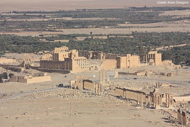
Palmyra, 2009 pre-war view from Qalaat Ibn Maan, Temple of Bel and colonnaded axis. (Photo Credit: Arian Zwegers via Wikimedia)