Mapping indigenous lands

World Resources Institute and a dozen other groups have launched a collaborative mapping project to document indigenous lands all over the globe. Incredibly exciting!

…up to 65 percent of the world’s land is held by Indigenous Peoples and communities, yet only 10 percent is legally recognized as belonging to them. The rest, held under customary tenure arrangements, is largely unmapped, not formally demarcated, and therefore invisible to the world. Starting today, anyone can view the detailed coordinates and borders of indigenous and community lands around the world using LandMark (www.landmarkmap.org), the first online, interactive global platform to map collectively held lands.


A great Wired article looks at Soviet military maps

A great new article to read (and see beautiful maps): Inside the Secret World of Russia’s Cold War Mapmakers | WIRED

The Soviet military mapped the whole world in incredible detail, not just for possible battlefields if another world war broke out, but also as a means of storing as much data as possible in a readily accessible and elegantly displayed format for intelligence and economic analysts in the pre-computer era. In the 1990s, after the Soviet Union had ended and the maps got out, the U.S. government and telecommunications companies used the maps of the developing world to supplement their own knowledge bases. The maps have also proven critical in guiding resolution of disputed borders because the Soviet cartographers had carefully examined and recorded all relevant historic details and documents that might influence them.

Mapping the projected Turkish occupation zone in Syria

Arsenal For Democracy estimates and maps the perimeter dimensions of Turkey’s potential occupation zone / U.S. no-fly zone in northern Syria. (The detail map is near the middle, after the evidence used to prepare it. A regional map showing the area in context is attached at the end.)

As I’ve explored previously, for the past month, the Turkish military and the Turkish government have been disagreeing quasi-publicly as to whether to invade and occupy northern Syria to establish a “humanitarian zone” (supposedly for refugees).

The military brass is trying to delay at least until a new government is formed and the newly-elected parliament can take a vote on it, while the ruling AK Party is pushing for an intervention sooner. It seems to have been an AK Party aspiration, off and on, since at least September 2014, whereas the military isn’t entirely sure it’s a good idea in a general.

On February 22, 2015, Turkey’s military staged a lightning incursion in and out Syria, moving more than 600 troops and 100 tanks along the Euphrates River for some 22 miles (35 km) and then returning to the Turkish border a few hours later. The objective then was ostensibly to secure and re-locate a historic tomb of national significance (which was being guarded by Turkish Special Forces in a vulnerable position). But it may have also served to test Turkey’s ability to invade that far into Syria’s warzones without major resistance, although it was on the other side of the river, south of Kobani.

Of course, a speedy raid and departure would be quite different from a full-scale intervention to hold territory indefinitely. So how big of an area are we actually talking about for this possible massive military operation?

Soner Cagaptay, the director of the Turkish Research Program at The Washington Institute, indicated in The Globalist in early July (based on “media reports”) that the zone would be as follows:

Specifically, Turkish forces may be aiming to seize a [88-km] 55-mile-long stretch of territory from Azaz in the west to Jarabulus in the east, thus establishing a [32-km] 20-mile-deep cordon sanitaire against the violence next door and creating a staging ground for pro-Turkey Syrian rebels.

 
Following meetings between U.S. and Turkish government officials this week, Turkey’s Hurriyet Daily News reported the latest rumors, which were far more expansive:

A recent joint action consensus between Turkey and the United States, which includes the use of the İncirlik Airbase in southern Turkey in fight against the Islamic State of Iraq and the Levant (ISIL) jihadists, also covers a partial no-fly zone over the Turkey-Syria border, according to sources.

The 90-kilometer line between Syria’s Mare [Marea] and Cerablus [Jarabulus] will be 40 to 50 kilometers deep, sources told daily Hürriyet, while elaborating on the consensus outlined by Deputy Prime Minister Bülent Arınç, following a cabinet meeting on July 22.

However, sources avoided saying whether such a zone would be broadened in the future.

 
In addition to that representing a larger area, this news also suggests Turkey’s longstanding demand of getting U.S. air support and a no-fly zone for such an operation may have been met.

If it comes to pass with those enlarged specifications, as depicted in the map below, the U.S.-patrolled no-fly zone and Turkish-occupied “humanitarian zone” on the ground in Syria is going to run to the edge of the city of Aleppo at minimum — and could theoretically even include the entire city (not depicted). That variance represents the aforementioned range of a 40-50 km depth from the border, which falls either on the north side of the city (leaving it out) or the south side (including it).

However, it seems unlikely to me that an initial zone would include Aleppo itself, simply because it has been the site of a protracted siege for several years and Turkey would have to break into it to take it over, while the U.S. would have to fight for air supremacy over the city. Of course, some hardline nationalists in Turkey have never gotten over the loss of Aleppo to the French and Syrians in the border-setting wars that followed the Ottoman Empire’s destruction in World War I.

Regardless of motivations, even stopping just short of Aleppo would put the Turkish military into position to provide direct military support to its allied opposition forces trapped in Aleppo. The Syrian Army would likely have to withdraw, and the Syrian Air Force might not be able to continue aerial attacks.

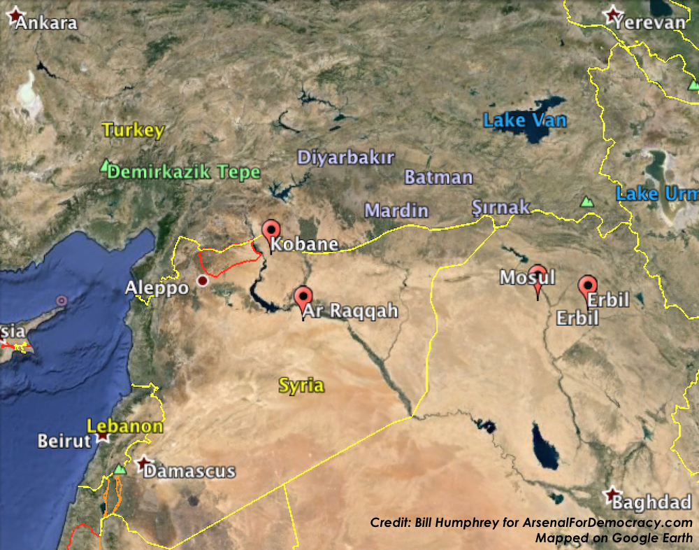
Below is my approximated projection of the minimum Turkish Occupation Zone based on various recent Turkish media descriptions, as well as (loosely upon) local highways and land features. In terms of west-east width, this is using the wider “Azaz in the west to Jarabulus in the east” parameter than the one reported in Hurriyet (Marea to Jarabulus). In terms of depth, it is using the much larger 40-50 km measurement from Hurriyet, at least on the southwest corner, where it seems most applicable.

July 24, 2015 projection of the perimeter of a potential Turkish occupation zone and no-fly zone in northern Syria. Click to enlarge.

July 24, 2015 projection of the perimeter of a potential Turkish occupation zone and no-fly zone in northern Syria. Click to enlarge.

First, a key observation: Manbij is located on the M4 highway. If Manbij is indeed the big southeast anchor point of the occupation zone, as even the conservative estimate would suggest, that highway not only forms a convenient southern perimeter line but also restricts ISIS movements westward from Raqqa. Moreover, it is the same road that extends to the Euphrates, to the precise spot where the Tomb of Suleyman Shah was located until it was moved in the February operation. So that might be another sign that the incursion was a test.

Second: That’s a pretty huge area, currently controlled (to my knowledge) almost entirely by ISIS and the Syrian Army, except for some of the western locations, which are held by Saudi-backed rebel groups that are theoretically also aligned with Turkey. They might, however, not be overly receptive to a Turkish military occupation in a predominantly Arab territory (though ethnic facts on the ground didn’t deter Turkey’s “peacekeeping” occupation of northern Cyprus in 1974, which hasn’t ended 41 years later). On either side of the Syrian zone are Syrian Kurdish forces and communities (including Kobani, across the Euphrates on the eastern side).

Third: The U.S. no-fly zone would reportedly be based out of Incirlik Air Base in Turkey (see our map) if that deal doesn’t fall apart again.

Fourth, a qualification, as I was taught to make at the University of Delaware Geography Department: keep in mind that I am looking at satellite and road maps with a somewhat limited familiarity with the area in question. Military conditions and physical features on the ground that I can’t see might make some of the lines way off.

[Added at 4:45 AM EDT: While I was writing this report, the wires broke the news that Turkish fighter jets began airstrikes across the border from the Turkish town of Kilis on ISIS targets inside Syria. You can see Kilis is directly north of the northwest corner of the zone mapped above, which means the targets are probably inside the zone. Turkey says the jets fired from within Turkish airspace.]

[Added at 6:25 PM EDT: The Turkish Foreign Ministry has confirmed that U.S. Air Force planes and other coalition partners will be permitted to fly armed and manned missions from Incirlik Air Base and bases at Diyarbakir and elsewhere. The Ministry did not confirm whether a no-fly zone was part of the deal.]

[Added at 3:30 AM EDT on July 25, 2015: And below is a zoomed-out map showing the same area drawn above, this time in red, but within the regional context.]

Regional View: July 24, 2015 projection of the perimeter of a potential Turkish occupation zone and U.S. no-fly zone in northern Syria. Click to enlarge.

Regional View: July 24, 2015 projection of the perimeter of a potential Turkish occupation zone and U.S. no-fly zone in northern Syria. Click to enlarge.


When is a disputed territory not disputed anymore?

Obviously the simple answer to that question is a matter of when everyone officially agrees to stop disputing it, but that may never happen in some cases. So how do we balance the long-term geopolitical realities on the ground with the higher-level political concerns? That answer is not so easy.

Several weeks ago, I published a (disapproving) essay on National Geographic’s decision to transfer Crimea from Ukraine to Russia on its maps as soon as annexation occurred. Given the extremely contested circumstances surrounding the referendum to leave Ukraine, I felt this was overly hasty and risked reinforcing Russian claims without good reason, before the dust had even settled.

David Miller, a former Senior Editor at National Geographic, tweeted us his very compelling blog post on how (in the abstract, beyond National Geographic specifically) one makes a decision on how to map disputed territories, since it is indeed a bit subjective (as I had argued).

In “Crimea: A Map Controversy”, Miller notes the deep controversy over the referendum (held essentially at Russian gunpoint amid major boycotts), and then he lays out some factors to weigh deciding when it’s time to flip control on the map:

For accurate mapping of political sovereignty, the cartographer should consider four points: political claim, control of territory, international recognition of sovereignty, and time.

 
Let’s take them one at a time, as he does in the piece.

He observes that the governments of Ukraine and Russia both claim the territory. So it’s disputed, but anyone can dispute anything indefinitely, which means you have to look at the other factors.

He also observes that Russia must have military, political, and economic control of the region. It’s getting pretty close, but at the time National Geographic made its decision, the Ukrainian military hadn’t even evacuated the peninsula. It still hasn’t fully right now, I believe.

On the third point, he observes that there’s very little international recognition for this move and probably won’t be. Even Russian allies, such as Serbia, are hesitant to acknowledge the action for fear of de-legitimizing their own opposition to separatism and other neighborhood border disputes.

You rarely achieve resolution on all these points, but of course it’s about subjectively weighing them against each other before you color in the map.

Finally, the most subjective — and probably most important — factor to consider: time.

Time determines whether sovereignty is enduring or fleeting. Months or years may be necessary to judge a country’s claim and control of a region. For example, Morocco has claimed Western Sahara as a part of Morocco for decades, but its political control is limited and sovereignty is disputed. When Iraq invaded and annexed Kuwait in 1990, Iraqi sovereignty was disputed, and then it was overturned in 1991.

 
Outside the context of mapping, here’s another example that came to my mind on the issue of factoring in time: The U.S./U.N. abandoning its recognition of the Republic of China (ROC) in Taiwan as the “legitimate government” of mainland China, three decades after the ROC had lost control of the mainland to the People’s Republic of China (PRC).

Objectively, in that situation, there was no fundamental change on the ground or between the factions in 1979 that suddenly signaled that the PRC was more legitimate and permanent than it had been in, say, 1965. I’m sure certain political actions in the 1960s (such as the PRC’s brutal “Cultural Revolution”) probably didn’t help speed up U.S. recognition, but — other than Mao finally dying in 1976 — it probably wouldn’t have been any less arbitrary to normalize relations in 1960, 1965, 1972, etc.

All of which is to say sometimes in sovereignty disputes you really do just wait around to see how things play out and then one day you wake up and say to yourself “yeah, I think we better just accept this is the situation.”

That’s an definitely arbitrary and subjective solution, but at least giving a situation time ensures that it actually is going to remain that way rather than being reverse in a few more weeks. Crimea probably is going to remain Russian indefinitely and probably won’t be reversed back to Ukrainian control any time in the foreseeable future. But that doesn’t mean it’s time to change the color on the map to match Russia’s the second the referendum ends.

Miller’s verdict:

At this time, Crimea should be shown as disputed territory, which is usually a gray color on National Geographic maps with no sovereignty color.

 
But I do encourage everyone to read the full post, as I have only drawn a few bites out here and there, and he is a far more qualified person to speak on this subject than I am.

Thanks for sending it our way! If other readers also have articles/essays on the matter, let us know, or post a comment.
crimea-ukraine

National Geographic, Crimea, and the politics of geography

crimea-ukraine
Above: Wikipedia’s map showing Crimea as part of Ukraine.

National Geographic, the venerable and often deeply controversial flagship organization of the American field of geography, has generated a new firestorm over its decision to start mapping Crimea as part of the Russian Federation following its illegal and fraudulent annexation of the peninsula. Other options would include marking it as “disputed” or still part of Ukraine. Nat Geo’s justification was that they “map the world as it is, not as people would like it to be.”

Whether or not the de facto status of Crimea is now that it is part of Russia, that’s a cop-out. And as someone who studied the history of geography at the University of Delaware’s nationally prominent Geography Department, I’d like to point out that this cop-out also conveniently absolves National Geographic of its role in the community and the world, one which has historically been both very important and very damaging (in many cases).
Read more